


Main Street: Nantucket, Massachusetts

Summary
Nantucket's Main Street is one of those American streets that defines the place it is located. Round, uneven cobblestones pavers bring an immediate sense of history and intimacy to Main Street whether a visitor is traveling by foot, bicycle, or car. Church spires, tree-shaded Greek Revival mansions, and the town's waterfront frame the views up and down the street. More than two dozen sidewalk benches, located next to the "Hub" and the local drug store, invite residents and visitors alike to sit and visit, watch the comings and goings of downtown Nantucket — or kids going sledding after a winter snowstorm.
Designated Area
Ten blocks between Quaker Road (Caton Circle) and Straight Wharf.
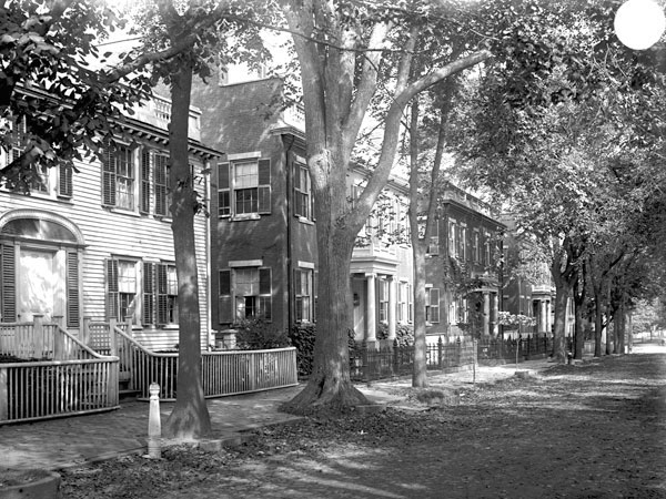
The Thomas H. Macy House and the homes known as the 'three bricks' reflect the Federal and Greek Revival styles, respectively, popular along Main Street. Photo courtesy Nantucket Historical Association.
Planning Excellence
Since the decline of the whaling industry in the 1840s, visitors and tourism have been the mainstay of the island's economy. Nantucket's population quintuples in the summer, crowding Main Street with pedestrians, cars, and commercial vehicles. The resulting congestion and traffic during the island's high season have been discussed for several years, including in the town's 2009 master plan.
The master plan also reaffirms the importance of the island's historic preservation guidelines and the investments by millionaire philanthropist Walter Beinecke, Jr., during the 1960s that protected the character of Main Street, what it contributes to the local economy, and the memories it instills.

Dancers wearing Santa hats abound during the annual Christmas Stroll on Main Street near the Pacific National Bank Building. Photo by Jim Powers, The Inquirer and Mirror.
Defining Characteristics, Features
History and character
- Original downtown settlement, Sherburne, dates to 1673; Straight Wharf, at the end of Main Street, built in 1723
- Cobblestones installed in 1837 to help keep mud out of street; lower portion of street widened in 1846 after fire destroys most buildings
- Lower Main Street commercial area, between Straight Wharf and Center Street, has one-way traffic; two-way traffic through residential area on upper Main closer to Quaker Road
- Houses and mansions of upper Main Street built in 19th century during whaling era; best-known are the "three bricks" between 93 and 97 Main Street — identical Greek Revival-style homes built by Joseph Starbuck between 1836 and 1838 for his three sons
- Other notable houses include the Richard Gardner House (139 Main St., prior to 1688); the Federal-style Thomas Macy House (99 Main St., 1770), Captain Edward Cary House (117 Main St., 1790s), and Henry Coffin House (75 Main St., 1835); the Greek Revival-style Hadwen House (96 Main St., 1845) and George Gardner houses at 110 and 141 Main St.; and the mid-Victorian Charles Robinson house (108 Main St., 1899)
- Pacific Club and former customs house at 1 Main Street (1772), and Pacific National Bank at 61 Main Street (1810), both survived 1846 fire
Planning milestones and challenges
- Historic District comprising part of Nantucket Island established in 1955, added to National Register in 1966; all of Nantucket becomes a local Historic District in 1971
- Sherburne Associates founded in 1957 by millionaire philanthropist Walter Beinecke, Jr.; Beinecke purchased large portions of town to preserve historic charm, appeal to wealthy visitors, and transform Main Street business district
- Zoning established in 1972; in 2003 Commercial Downtown District adopted, allows increased building heights to match current buildings and increased lot usage for maximum density
- Formula Business Exclusion District Overlay enacted in 2006 to preserve character of Main Street by restricting "formula businesses" (i.e. national chain stores and franchises, restaurants, take-out and bars)
- Limited areas for parking (300 on-street spaces in downtown core, angle parking along commercial portion of Main) insufficient during summer months; 2009 Master Plan suggests ways to limit cars during tourist season
- Ballot referendum (2006) and reports by the Urban Land Institute (2008) and the University of Connecticut (2009) address parking and congestion issues
- Nantucket Regional Transit Authority's nine seasonal fixed bus routes provide access to Main Street, airport, park and ride lots
Community and island culture
- Intersection of Main Street and Quaker Road was known as Russell Square but in 1958 was renamed Caton Circle for Casimiro Caton in recognition of his efforts to beautify this section of Main Street, including the decoration of Christmas trees and tending the circle as a garden, a tradition carried on by his son and daughters; immigrants and their children continue to play an important role on Nantucket
- Well-known local residents "claim" — via name plates — some of the 25 benches along Main Street
- "For some odd, sentimental reason," says one resident, "it is still a thrill, no matter how many times we do it, to go bouncing up Main Street in a car."
- Bartlett Farm, Nantucket's oldest farm, has sold produce and flowers from a truck on Main daily during the summer since the 1930s; a monument to Mr. June Bartlett stands on the west side of the street
- Main Street home to local celebrations: Daffodil Festival with antique car show, Fourth of July Parade, Halloween Parade, Christmas Stroll with Santa and Mrs. Claus, Christmas Eve raffle

Classic and antique cars and hundreds of bouquets of daffodils line Main Street for the annual Daffodil Festival. Nantucket residents and visitors gather on Main Street throughout the different seasons for numerous special events and celebrations. Photo by Jim Powers, The Inquirer and Mirror.