Transforming Boston's Moakley Park to Equitably Address Climate Change

Moakley Park has long been a part of the South Boston landscape and identity, but not always for the right reasons. Originally a salt marsh and mudflat, Moakley has been unofficially used for recreation since 1909, when it served as both a garbage dump and a playground. Filled in 1919 with harbor-dredged clay, the site's flat profile and impermeable soil wreak havoc today when mild rain events cause flooding, too often leaving recreational amenities unusable.
In addition to rain-driven flooding, Moakley's topography means it offers little protection from projected sea level rise caused by climate change. Access to the park and beach is also a significant challenge, thanks to its adjacency to high-speed roadways. There are also significant equity challenges, particularly considering that its 60 acres sit so close to two public housing developments and the multi-racial, multi-ethnic neighborhoods of Dorchester and Roxbury, and yet there are few amenities for those residents, despite its ample space.
The Moakley Park Resilience Plan transforms an underutilized, flood-prone sports park into a resilient, inclusive, and multi-faceted 21st-century open space that serves nearby communities and creates a new harborfront destination for the entire city.
Accessible by public transportation and within 15 minutes of many neighborhoods, Moakley is poised to address the city's most pressing climate resilience, social justice, and community health and welfare priorities. It could also create a waterfront terminus for Frederick Law Olmsted's signature Emerald Necklace, a 19th-century park system whose final link to Boston Harbor remains unrealized.

The proposed redesign of Moakley Park will transform Boston's largest harborfront park into a model for climate resiliency and inclusive and equitable design. Photo ©Alex Maclean Landslides/ Drawing ©Stoss.
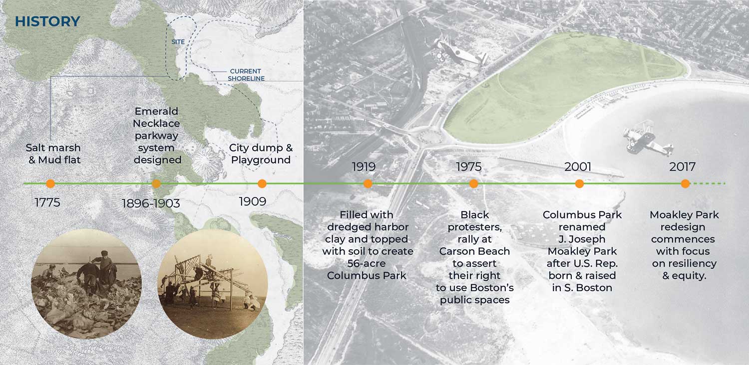
Moakley Park development timeline. Image © Stoss Landscape Urbanism.
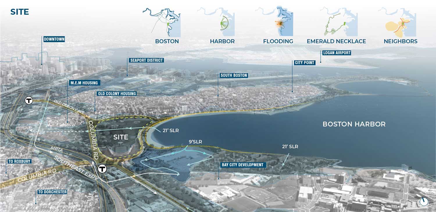
Moakley Park within its urban and waterfront context, highlighting projected coastal inundation to the park and adjacent neighborhoods. Image ©Stoss Inc.
Challenges Facing Boston's Moakley Park
Moakley Park is just a short bicycle or subway ride from the city's Financial District, Chinatown, and South End. It is Boston's largest harborfront park, with potential views of the harbor and islands beyond, but it is challenged on several physical, social, and environmental fronts. It inhabits a poignant place in the city's history, as well, as the site where in 1975 Black protestors converged to protest discrimination and assert their right to use Boston's public open spaces.
Two public housing developments with significant BIPOC communities are adjacent, yet offer little for kids, families, and elders to do. Access is impeded by treacherous multi-lane, high-speed roadways, and its sparse tree canopy offers little relief from the sun and heat.
Its waterfront location poses significant risks — to the park, adjacent neighbors, nearby infrastructure, and to several current and future redevelopment sites within a half-mile radius. Sea level rise projections predict a 21 to 40-foot rise within 50 to 60 years. At 40 feet, during a 1 percent storm, flood waters entering through the park join two other flood pathways, catastrophically sending water deep into surrounding areas. A complex web of underground utilities and challenging geotechnical conditions further impinge the design.
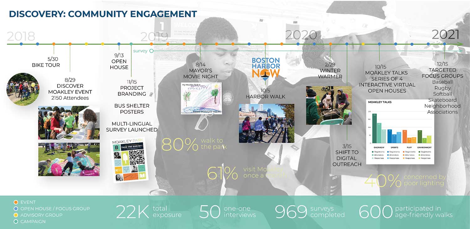
Summary of Moakley Park engagement activities, which are ongoing. Image © Stoss Inc.
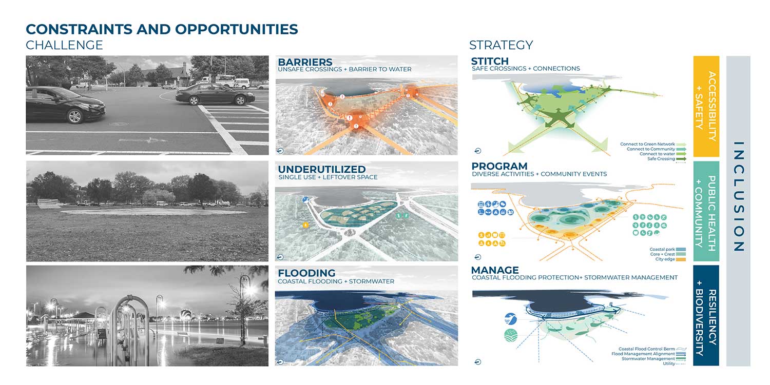
The challenges and opportunities of the project are multidimensional. Image ©Stoss Inc.
Engagement Unveils Moakley Park Opportunities
Yet, in addressing these resiliency and infrastructural challenges, compelling new opportunities emerge to embed solutions for other known community risks and long-standing conditions, especially for the park's lower-income and BIPOC neighbors. Many of these surfaced through deep community engagement and expansive outreach.
Before COVID-19, the foundation of the engagement strategy was community open houses and on-site events, including "Discover Moakley!" — a daylong community event organized to bring fun and energy to the park with local vendors, an activated street, and booths for community input and resiliency education. These efforts were amplified with digital and physical surveys, one-on-one interviews, and mapping activities, all of which allowed the team to initiate conversations with community members about its current use and their hopes for the park's future. Because of the pandemic, the planning and design team from Stoss Landscape Urbanism shifted to include strategies such as online surveys, virtual tours, and interactive video meetings.
The project is being led by Boston's Parks and Recreation Department but stems from the city's Climate Ready Boston (CRB) initiative (an APA National Planning Award recipient), which addresses projected climate impacts across the city on a district-by-district level. Moakley Park is unique as the single largest flood-prone property owned by the city, though technical and jurisdictional complexities abound.
Given this, the parks department is coordinating across both city and state agencies that include Environment, Planning and Development, Public Facilities, Transportation, MassDOT, and the MA Department of Conservation and Recreation. The team has also formed critical partnerships to expand reach and garner diverse input, including with the non-profit Boston Harbor Now, as well as embedded community leaders and community organizations. The initiative is also spurring explorations of new governance structures for the park that would more deeply engage traditionally underrepresented populations (including developing jobs programs, etc.), and bridge gaps between city, state, and other jurisdictional lines. Capital funding is expected to come from public sources at the federal, state, and city levels, as well as private sources.
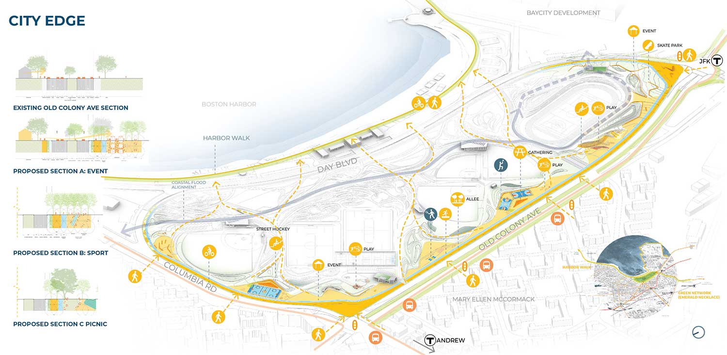
The City Edge zone creates new uses and activities. Image © Stoss Inc.
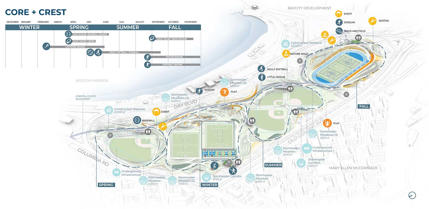
The Core and Crest zone provides athletic opportunities. Image © Stoss Inc.
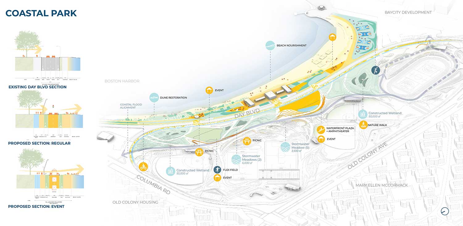
The Coastal Park zone offers biodiverse and resilient landscapes. Image © Stoss Inc.
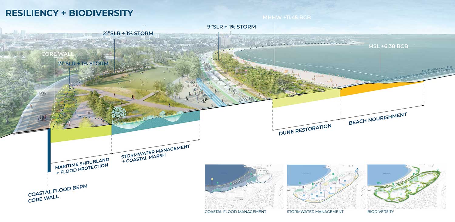
Moakley Park resilience strategies integrate coastal flood protection, stormwater marshes, extensive tree canopy planting, biodiversity, and urban heat island reduction initiatives. Image © Stoss Inc.
Park Design Balances Nature and Resilience
The proposed design organizes the park into three parallel zones to address the complex, overlapping challenges. The City Edge creates a string of new uses and activities programmed to a full range of age groups, offering immediate activity close to existing residents and beneath an extensive tree-lined promenade, with running paths, raised bicycle lanes, and seating.
The Core and Crest is a series of four sport and athletic rooms with improved recreational fields in the center of the park, surrounded by lush and diverse landscapes, sitting and garden groves, and new destination areas, such as a nature play area.
The Coastal Park introduces new coastal landscapes of dunes, marsh, and bird habitat, integrated with a multipurpose waterfront plaza and amphitheater and a new beachfront promenade that links the park to the beachfront. Together, different combinations of activities and planted areas offer city residents a park to experience over an entire day and into the evening, mixing people and new uses into biodiverse and resilient landscapes.
Resilience strategies address multiple climate factors. The coastal flood management strategy is integrated throughout the park and is designed to provide both environmental and social benefits. An engineered flood-protection wall is embedded into the topography and runs the length of the park, creating new nodes for play, exploration, year-round recreation, and improved biodiversity. Sited on the edge between the Core and Crest and the Coastal Park, the highpoint of the berm offers views into the park and panoramas out to the harbor, which have never before been possible.
Innovative green infrastructure strategies are incorporated and distributed across the site, including stormwater meadows, corridors, tree trenches, and porous pavements. The site will also see a reduction in urban heat island effect and an increase in biodiversity through the planting of over 500 new trees and a mix of native plants including coastal marsh species, maritime shrublands, and woodland flora.
The Moakley Park Resiliency Plan represents a rare opportunity to create a modern, 21st-century community park that addresses pressing climate change needs while also prioritizing social, cultural, economic, and environmental equity. The planning process has been inclusive, deliberative, and responsive to community needs. It will result in a park that is safer, biodiverse, culturally rich, recreationally diverse, and welcoming to all residents and visitors.
Top Image: Rendering of Moakley Park. Image provided by Stoss Landscape Urbanism


