


Elisabeth May Herlihy: A Matriarch of Urban Planning in Boston
summary
- Elisabeth May Herlihy was a pioneering woman planner who served on the Boston City Planning Board in 1914.
- She was the first female member of the American City Planning Institute (ACPI), an early predecessor of the American Planning Association (APA).
- Herlihy was instrumental in the research and analysis of Boston's street systems.
In the early twentieth century, Boston, like many cities, was experiencing rapid population growth. The city's historic road infrastructure, with its narrow, discontinuous streets, already limited the movement of people and goods. The emergence of the automobile on roadways compounded this, making Boston's congested streets a primary concern among city officials. Without intervention, the economy would suffer; further, its antiquated thoroughfares posed a threat to public safety.
During this period, urban planning was taking shape as a profession: among its ranks arose a formidable woman to shepherd a new era of Boston's structure and development. Elisabeth May Herlihy (1880-1953) was a rare woman in a field dominated by men, yet she dedicated decades to improving the city's built environment.
From shaping zoning policy to advancing the study of traffic and transportation planning in a rapidly modernizing city, Herlihy's story is one of perseverance in a profession that offered few opportunities for women during her lifetime.
Pursuing an Unconventional Career
Herlihy was born in Wilton, New Hampshire, to Irish immigrant parents who came to the United States to escape the famine. Instead of following the traditional path expected of women by society, Herlihy pursued a career, moving to Boston to train for clerical work — one of the few professional avenues open to women at the time. She eventually became Mayor John F. Fitzgerald's right hand as chief clerk, overseeing much of the city's administrative work.
In 1913, Herlihy successfully persuaded Fitzgerald to appoint her as secretary of the proposed city planning board, which was officially established by ordinance in January 1914. The title of "secretary" does little justice to Herlihy's contributions in the early years of the Boston City Planning Commission; she became deeply involved in research, policy development, and communication between city officials and planning experts.
Although Herlihy's entry into planning was unconventional, her ambition and natural aptitude for urban planning and policy made her indispensable, thereby enhancing her professional stature.
First female to join ACPI
By 1927, despite her lack of formal credentials, Herlihy was invited to join the American City Planning Institute (ACPI), an early predecessor of the American Planning Association (APA). Herlihy's induction was historic, albeit controversial for its time: she was the first female member to join ACPI's ranks, a testament to her expertise and leadership in urban planning.
As the decades progressed, so did Herlihy's career and prominence in the planning profession. In 1935, she was appointed chair of the Massachusetts Planning Board, further expanding her influence beyond Boston. She continued to serve Boston as commissioner on the Boston City Planning Board until her retirement in 1950, cementing her legacy as a stalwart figure through successive mayors.
As Eugenie L. Birch, FAICP, notes in her paper, "From Civic Worker to City Planner, Women in Planning, 1890-1980," an observer was quoted as saying, "Mayors came and went, but Elisabeth Herlihy was as permanent as the planning board."
Shaping Boston's Planning Framework
During the first decade of Herlihy's service with the Boston City Planning Board, she was a key figure in the city's adoption of its first comprehensive zoning framework (1924), a major milestone in the city's planning history.
Her work also extended into transportation planning, an area that was becoming increasingly urgent as automobile traffic surged in American cities. Studies conducted by the Boston City Planning Board analyzed traffic patterns, street capacity, and the movement of goods and people through the city. These studies were part of an effort to understand how Boston's historic street network could adapt to modern transportation demands.
The Report on a Thoroughfare Plan for Boston (1930) examined traffic congestion and proposed strategies for improving circulation through the city. As secretary, Herlihy contributed research and analysis on Boston's street system, helping to build a data-driven understanding of how the city functions and how its infrastructure might change to meet modern demands. For Boston, this entailed proposing a network of primary routes to efficiently move traffic across the city.
Focus on Transportation Infrastructure
Ideas developed during the early years of the Boston City Planning Board would eventually inform the construction of the Central Artery, an elevated highway that bisected Boston. Although Herlihy did not design the Central Artery itself, her work on traffic studies and thoroughfare planning helped shape the thinking that ultimately led to its construction. This included the view that modern transportation infrastructure was essential to economic vitality and urban growth.
The report identified the need for transportation routes that could carry traffic across the city while relieving pressure on local streets. Still, by the late 1940s, concerns about congestion had expanded beyond Boston itself to the entire metropolitan region.
In 1948, planners produced the Master Highway Plan for the Boston Metropolitan Area, prepared by engineer Charles A. Maguire under the supervision of a joint planning board that included Herlihy. The plan proposed an extensive highway network to improve regional mobility and alleviate traffic congestion throughout Greater Boston. Its recommendations formed the state transportation policy that led to the passage of a $100 million highway program in 1950, including what would become known as the Central Artery.
Construction of the Central Artery began in 1951, near the end of Herlihy's long career in planning. By that time, she had spent more than three decades working to modernize Boston's planning systems and transportation studies.

Aerial view of Boston, Massachusetts (1957) from Beacon Hill, showing the Central Artery freeway, buildings, and Charles River. Image courtesy of the Library of Congress's Prints and Photographs Division.
Although she had retired from the Boston City Planning Board the year before construction began, the project was held up as a solution to concerns planners like Herlihy had grappled with for decades: congestion, mobility, and the challenge of adapting historic cities to the demands of modern transportation.
At the time, the Central Artery was widely viewed as a necessary step toward modernization and thus, beneficial to the public. The highway was expected to alleviate traffic congestion and support the growing regional economy by enabling automobiles and commercial vehicles to travel more quickly through Boston.
Its construction, however, came at a high price: it is estimated that 20,000 residents were displaced, a significant portion of whom were people of color, to make way for the Central Artery. The elevated highway dramatically cut into several diverse neighborhoods, including Chinatown, the West End, and downtown.
Rethinking the Benefits and Costs of the Central Artery
In subsequent decades, historians and planners would cite projects such as the Central Artery as examples of how a singular focus on highways and urban renewal, rather than on community preservation, reinforced patterns of displacement and segregation. Similar highway projects across the United States disrupted or eliminated established neighborhoods, particularly those home to working-class residents and immigrant communities.
By the late twentieth century, Boston sought to address many of the highway's most visible harms. Beginning in the 1990s, the highway was dismantled and replaced with an underground tunnel system, known as the Big Dig, designed to move traffic beneath the city rather than through its surface streets.
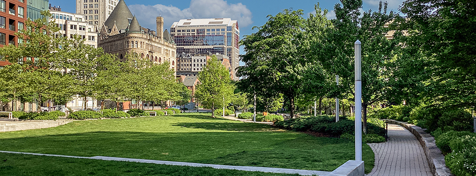
In its place, the city created the Rose Kennedy Greenway, a series of parks and public spaces stretching through the heart of the city. These open spaces helped reconnect neighborhoods that had been separated for decades and restored pedestrian access between downtown, the waterfront, and nearby communities.

Map of the Rose Fitzgerald Kennedy Greenway, a linear park, at its North End park adjacent to the North End neighborhood. Photo: iStock Unreleased, APCortizasJr.
The Central Artery is illustrative of the evolving nature of urban planning. Herlihy and her contemporaries were responding to the urgent challenges of their time: rapid population growth, expanding automobile traffic, and infrastructure systems that struggled to keep pace with modernization. The tools and priorities available to planners in the early twentieth century differed significantly from those guiding the profession today.
Looking back, planners now recognize the social and environmental consequences that large-scale infrastructure projects can have on communities. Modern planning practice places greater emphasis on equity, public engagement, and the long-term impacts of development decisions.
A Lasting Legacy
Elisabeth May Herlihy's career spanned a formative period of urban planning in the United States and is representative of the evolution of the planning profession. Through her work with the Boston City Planning Board, she helped shape the city's zoning policies, transportation studies, and institutional planning framework, laying the foundation for a field that continues to adapt and reassess its role in shaping municipalities.
Equally important, Herlihy's professional achievements signaled a breakthrough for women in the field. At a time when few women held positions of authority in municipal government or professional organizations, Herlihy broke barriers and rightfully earned the respect of her colleagues.
More than a century after she began her work with the city of Boston, Elisabeth May Herlihy's legacy remains part of the city's ongoing story of growth, adaptation, and renewal. It also reflects both the early ambitions of the planning profession and its continuing responsibility to learn from the past while shaping more thoughtful cities for the future.
Top Image: Boston skyline and the Rose Fitzgerald Kennedy Greenway. iStock/Getty Images Plus - bauhaus1000.
About the Author